
Plik:Gunung Klabat.jpg
Grafika w wyższej rozdzielczości nie jest dostępna.
Gunung_Klabat.jpg (640 × 428 pikseli, rozmiar pliku: 52 KB, typ MIME: image/jpeg)
| Plik Gunung Klabat.jpg znajduje się w Wikimedia Commons – repozytorium wolnych zasobów. Dane z jego strony opisu znajdują się poniżej. |
| Opis |
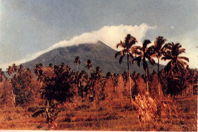
English: Weather clouds drape the summit of Gunung Klabat, an isolated symmetrical stratovolcano that rises to 1995 m near the eastern tip of the northern arm of Sulawesi. Klabat, rising above the farming village of Tatelu below its NW flank, has a shallow lake in its 170 x 250 m summit crater. No verified historical eruptions have occurred from Klabat volcano, the highest peak in northern Sulawesi. |
|||
| Data | ||||
| Źródło | http://www.volcano.si.edu/world/volcano.cfm?vnum=0606-12=&volpage=photos&photo=063054 | |||
| Autor | S. Wikartadipura (Volcanological Survey of Indonesia) | |||
| Licencja (Ponowne użycie tego pliku) |
|

Historia pliku
Kliknij na datę/czas, aby zobaczyć, jak plik wyglądał w tym czasie.
| Data i czas | Miniatura | Wymiary | Użytkownik | Opis | |
|---|---|---|---|---|---|
| aktualny | 19:07, 26 lip 2010 | | 640 × 428 (52 KB) | Michael Metzger | {{Information |Description={{en|1=Weather clouds drape the summit of Gunung Klabat, an isolated symmetrical stratovolcano that rises to 1995 m near the eastern tip of the northern arm of Sulawesi. Klabat, rising above the farming village of Tatelu below i |
Lokalne wykorzystanie pliku
Poniższa strona korzysta z tego pliku:
Globalne wykorzystanie pliku
Ten plik jest wykorzystywany także w innych projektach wiki:
- Wykorzystanie na ca.wikipedia.org
- Wykorzystanie na cs.wikipedia.org
- Wykorzystanie na de.wikipedia.org
- Wykorzystanie na en.wikipedia.org
- Wykorzystanie na es.wikipedia.org
- Wykorzystanie na eu.wikipedia.org
- Wykorzystanie na fr.wikipedia.org
- Wykorzystanie na id.wikipedia.org
- Wykorzystanie na ja.wikipedia.org
- Wykorzystanie na jv.wikipedia.org
- Wykorzystanie na ko.wikipedia.org
- Wykorzystanie na lv.wikipedia.org
- Wykorzystanie na ms.wikipedia.org
- Wykorzystanie na pt.wikipedia.org
- Wykorzystanie na sk.wikipedia.org
- Wykorzystanie na uk.wikipedia.org
- Wykorzystanie na www.wikidata.org
- Wykorzystanie na zh.wikipedia.org