
Plik:Kwajalein Atoll 2003-02-07 - Landsat 7 - 30m.png

Rozmiar pierwotny (3786 × 2876 pikseli, rozmiar pliku: 12,22 MB, typ MIME: image/png)
| Plik Kwajalein Atoll 2003-02-07 - Landsat 7 - 30m.png znajduje się w Wikimedia Commons – repozytorium wolnych zasobów. Dane z jego strony opisu znajdują się poniżej. |
Opis
| Opis |
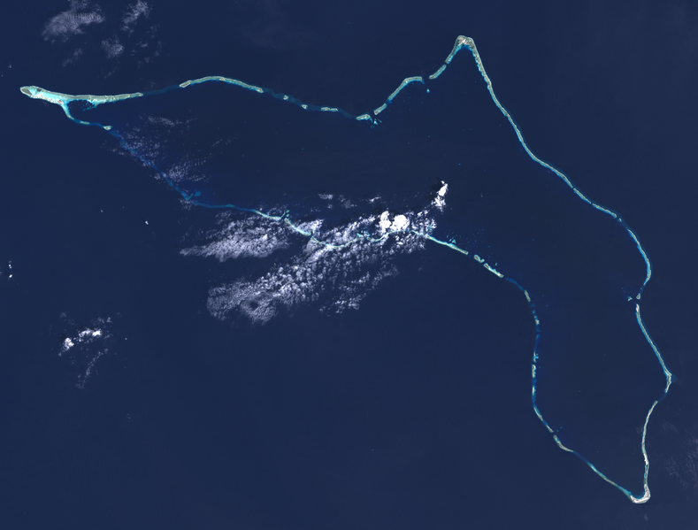
English: Composite "true color" multispectral satellite image of Kwajalein Atoll, Republic of Marshall Islands.
NASA Landsat 7 ETM+ bands used were 3 (red), 2 (green) and 1 (blue), and the image was pan-sharpened to 15m resolution, manually color balanced, and resampled to 30m output resolution. Projection: UTM (zone 58), WGS84. Imagery courtesy NASA/USGS. Much of what appears to be land in this image is actually underwater, you can see the blue tint to those areas. Kwajalein Island is the southernmost island, at the bottom right of the image. This is the center of US operations in the atoll, and the most heavily settled. Directly above it is Ebeye, the main Marshallese settlement in the atoll. A causeway runs north from Ebeye to create a string of connected islands. Some distance to the north of Ebeye, just below the middle of the right side of the image, are three small islands roughly in a triangle. The southeastern one is Meck Island, which holds a major US Army rocket testing facility. Launches are sometimes carried out from Omelek, the next island north of the cluster of three. Roi-Namur island, the second largest in the atoll, forms the northernmost location in the atoll, roughly top-center in the image. It hosts a number of large radars originally set up by ARPA and Lincoln Laboratories, but later turned over to the Army. On the extreme left is Ebadon, formerly the second largest island in the atoll before Roe and Namur were backfilled to turn them into one larger island. This island, along with a few islands to its east, were formerly a major Marshallese settlement, but many of the people moved to be closer to the US installations. The long string of islands between Ebadon and Kwajalein are relatively scarcely settled. Illegini, just east of due south of Roi-Namur, roughly the mid-point of the chain, used to be used for missile testing in conjunction with Meck, but now is used only for remote radar and camera systems. |
| Data | |
| Źródło | NASA/USGS Landsat satellite image GeoTIFF archive, http://glovis.usgs.gov |
| Autor | NASA |
| Pozycja fotografa | | To i inne zdjęcia na: OpenStreetMap |
|---|
Per-channel manual histogram stretch, 0.3 wt unsharp mask, mild saturation / contrast adjustments. ImageJ, pngcrush.
Licencja
| Ten plik jest w domenie publicznej ponieważ został stworzony przez NASA. Polityka praw autorskich NASA stwierdza, że „materiały NASA nie są chronione prawami autorskimi, chyba że zapisano inaczej”. (NASA copyright policy lub JPL Image Use Policy). | ||
 |
Uwaga:
|
Historia pliku
Kliknij na datę/czas, aby zobaczyć, jak plik wyglądał w tym czasie.
| Data i czas | Miniatura | Wymiary | Użytkownik | Opis | |
|---|---|---|---|---|---|
| aktualny | 20:40, 7 lip 2014 | | 3786 × 2876 (12,22 MB) | Разрывные | User created page with UploadWizard |
Lokalne wykorzystanie pliku
Poniższa strona korzysta z tego pliku:
Globalne wykorzystanie pliku
Ten plik jest wykorzystywany także w innych projektach wiki:
- Wykorzystanie na ar.wikipedia.org
- Wykorzystanie na ast.wikipedia.org
- Wykorzystanie na ca.wikipedia.org
- Wykorzystanie na ceb.wikipedia.org
- Wykorzystanie na en.wikipedia.org
- Wykorzystanie na en.wikivoyage.org
- Wykorzystanie na es.wikipedia.org
- Wykorzystanie na eu.wikipedia.org
- Wykorzystanie na fr.wikipedia.org
- Wykorzystanie na fr.wiktionary.org
- Wykorzystanie na he.wikipedia.org
- Wykorzystanie na he.wikivoyage.org
- Wykorzystanie na hu.wikipedia.org
- Wykorzystanie na id.wikipedia.org
- Wykorzystanie na it.wikivoyage.org
- Wykorzystanie na ja.wikivoyage.org
- Wykorzystanie na ka.wikipedia.org
- Wykorzystanie na lv.wikipedia.org
- Wykorzystanie na mt.wikipedia.org
- Wykorzystanie na ro.wikipedia.org
- Wykorzystanie na ru.wikinews.org
- Wykorzystanie na simple.wikipedia.org
- Wykorzystanie na tr.wikipedia.org
- Wykorzystanie na uk.wikipedia.org
- Wykorzystanie na ur.wikipedia.org
- Wykorzystanie na www.wikidata.org
- Wykorzystanie na zh.wikipedia.org
- Wykorzystanie na zh.wikivoyage.org