
Plik:Romania-WW1-1.jpg
Rozmiar pierwotny (1036 × 862 pikseli, rozmiar pliku: 149 KB, typ MIME: image/jpeg)
| Plik Romania-WW1-1.jpg znajduje się w Wikimedia Commons – repozytorium wolnych zasobów. Dane z jego strony opisu znajdują się poniżej. |

|
This map has been uploaded by Electionworld from en.wikipedia.org to enable the |
Opis
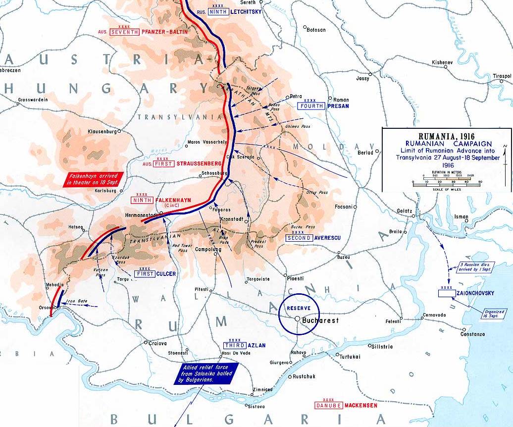
This map shows the Romanian attacks into Austria-Hungary in August of 1916.
This map was created by the Department of Military Art and Engineering, at the U.S. Military Academy (West Point). The initial version was created under the supervision of General Vincent Esposito in 1959. It is now available on the West Point web site at: http://www.dean.usma.edu/history/web03/atlases/great%20war/great%20war%20%20pages/great%20war%20map%2036.htm
The map image has been cropped to remove unneeded territory.
Licencja
Ten utwór znajduje się w domenie publicznej w Stanach Zjednoczonych, ponieważ jest utworem Rządu Federalnego Stanów Zjednoczonych w rozumieniu Tytułu 17, Rozdziału 1, Sekcji 105 Kodeksu Stanów Zjednoczonych. Zobacz także artykuł prawo autorskie.
Uwaga: Przepis niniejszy stosuje się wyłącznie do utworów Rządu Federalnego. Nie ma natomiast zastosowania do utworów jakiegokolwiek pojedynczego stanu lub terytorium (state, commonwealth, territory), utworów hrabstw (county), utworów miast i gmin (municipality) czy utworów jakiejkolwiek innej jednostki terytorialnej.
|
 | |
| Plik rozpoznano jako wolny od znanych ograniczeń praw autorskich, włącznie z prawami zależnymi i pokrewnymi. | ||
derivative works
Prace pochodne od tego pliku: CampañaRumanaAgostoSeptiembre1916.svg
Historia pliku
Kliknij na datę/czas, aby zobaczyć, jak plik wyglądał w tym czasie.
| Data i czas | Miniatura | Wymiary | Użytkownik | Opis | |
|---|---|---|---|---|---|
| aktualny | 18:43, 28 gru 2006 | | 1036 × 862 (149 KB) | Electionworld | {{ew|en|Cglassey}} == Summary == This map shows the Romanian attacks into Austria-Hungary in August of 1916. This map was created by the Department of Military Art and Engineering, at the U.S. Military Academy (West Point). The initial version was create |
Lokalne wykorzystanie pliku
Następujące strony korzystają z tego pliku:
Globalne wykorzystanie pliku
Ten plik jest wykorzystywany także w innych projektach wiki:
- Wykorzystanie na ar.wikipedia.org
- Wykorzystanie na azb.wikipedia.org
- Wykorzystanie na ba.wikipedia.org
- Wykorzystanie na be-tarask.wikipedia.org
- Wykorzystanie na be.wikipedia.org
- Wykorzystanie na ca.wikipedia.org
- Wykorzystanie na cs.wikipedia.org
- Wykorzystanie na de.wikipedia.org
- Wykorzystanie na el.wikipedia.org
- Wykorzystanie na en.wikipedia.org
- Wykorzystanie na es.wikipedia.org
- Wykorzystanie na fr.wikipedia.org
- Wykorzystanie na he.wikipedia.org
- Wykorzystanie na hu.wikipedia.org
- Wykorzystanie na it.wikipedia.org
- Wykorzystanie na ja.wikipedia.org
- Wykorzystanie na nl.wikipedia.org
- Wykorzystanie na pt.wikipedia.org
- Wykorzystanie na ro.wikipedia.org
- Wykorzystanie na ru.wikipedia.org
- Wykorzystanie na sr.wikipedia.org
Pokaż listę globalnego wykorzystania tego pliku.