
Plik:Tokyo Metropolitan Expressway map.svg

Rozmiar pierwotny (Plik SVG, nominalnie 6048 × 8688 pikseli, rozmiar pliku: 584 KB)
| Plik Tokyo Metropolitan Expressway map.svg znajduje się w Wikimedia Commons – repozytorium wolnych zasobów. Dane z jego strony opisu znajdują się poniżej. |
See the talk page for a larger legible image (1024 px).
- Other Versions

| Ten utwór został udostępniony jako własność publiczna przez jego autora, SPUI. Dotyczy to całego świata. W niektórych krajach może nie być to prawnie możliwe, jeśli tak, to: |
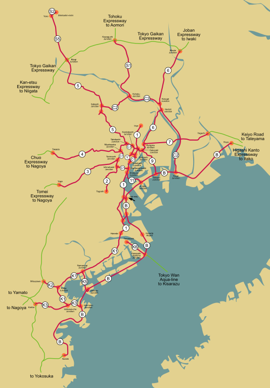
Map of the Tokyo Metropolitan Expressway network (red) and connecting expressways (green).
| # | Name (jp) | Name (en) | Description | Connections |
|---|---|---|---|---|
| 環状線 (belt highways) | ||||
| C1 | 高速都心環状線 | Inner Circular* | 環状線部分 (full belt) | |
| C2 | 高速中央環状線 | Central Circular | 西新宿JCT (Nishi-Shinjuku Junction) to 葛西JCT (Kasai Junction) | |
| 放射線 (radial highways) | ||||
| 1 | 高速1号上野線 | Ueno* | 江戸橋JCT (Edobashi Junction) to 入谷 (Iriya) | |
| 1 | 高速1号羽田線 | Haneda* | 浜崎橋JCT (Hamazaki-bashi Junction) to 羽田 (Haneda) | |
| 2 | 高速2号目黒線 | Meguro | 一ノ橋JCT (Ichinohashi Junction) to 戸越 (Togoshi) | |
| 3 | 高速3号渋谷線 | Shibuya* | 谷町JCT (Tanimachi Junction) to 用賀 (Yoga) | 東名高速道路 (Tomei Expressway) |
| 4 | 高速4号新宿線 | Shinjuku* | 三宅坂JCT (Miyakezaka Junction) to 高井戸 (Takaido) | 中央自動車道 (Chuo Expressway) |
| 5 | 高速5号池袋線 | Ikebukuro* | 竹橋JCT (Takebashi Junction) to 美女木JCT (Bijogi Junction) | |
| 6 | 高速6号向島線 | Mukojima* | 江戸橋JCT (Edobashi Junction) to 堀切JCT (Horikiri Junction) | |
| 6 | 高速6号三郷線 | Misato* | 小菅JCT (Kosuge Junction) to 三郷JCT (Misato Junction) | 常磐自動車道 (Joban Expressway) |
| 7 | 高速7号小松川線 | Komatsugawa | 両国JCT (Ryogoku Junction) to 谷河内 (Yagochi) | 京葉道路 (Keiyo Road) |
| 9 | 高速9号深川線 | Fukagawa* | 箱崎JCT (Hakozaki Junction) to 辰巳JCT (Tatsumi Junction) | |
| 10 | 高速10号晴海線 | Harumi* | 晴海 (Harumi) to 東雲JCT (Shinonome Junction) | |
| 11 | 高速11号台場線 | Daiba* | 芝浦JCT (Shibaura Junction) to 有明JCT (Ariake Junction) | |
| S1 | 高速川口線 | Kawaguchi* | 江北JCT (Kohoku Junction) to 川口JCT (Kawaguchi Junction) | 東北自動車道 (Tohoku Expressway) |
| その他の路線 (other routes) | ||||
| Y | 高速八重洲線 | Yaesu | 神田橋JCT (Kandabashi Junction) to 汐留JCT (Shiodome Junction) plus a branch from 西銀座JCT to 京橋JCT | |
| B | 高速湾岸線 | Bayshore* | 川崎浮島JCT (Kawasaki-ukishima Junction) to 高谷 (Koya) | 東関東自動車道 (Higashi Kanto Expressway) |
| - | 高速湾岸分岐線 | Bayshore branch | 昭和島JCT to 東海JCT | |
| 神奈川線 (Kanagawa routes) | ||||
| K1 | 高速神奈川1号横羽線 | Yokohane* | 羽田 (Haneda) to 石川町JCT (Ishikawa-cho Junction) | |
| K2 | 高速神奈川2号三ツ沢線 | Mitsusawa | 金港JCT (Kinko Junction) to 三ツ沢 (Mitsuzawa) | unknown expressway |
| K3 | 高速神奈川3号狩場線 | Kariba | 本牧JCT (Honmoku Junction) to 狩場 (Kariba) | unknown expressway |
| K5 | 高速神奈川5号大黒線 | Daikoku | 生麦JCT (Namamugi Junction) to 大黒JCT (Daikoku Junction) | |
| K6 | 高速神奈川6号川崎線 | Kawasaki | 殿町 (Tonomachi) to 川崎浮島JCT (Kawasaki-ukishima Junction) | 東京湾アクアライン (Tokyo Wan Aqua-line) |
| B | 高速湾岸線 | Bayshore* | 並木 (Namiki) to 川崎浮島JCT (Kawasaki-ukishima Junction) | unknown expressway |
| 埼玉線 (Saitama routes) | ||||
| S2 | 高速埼玉新都心線 | Saitama Shintoshin | 与野 (Yono) to 新都心 (Shintoshin-nishi) | |
| S5 | 高速埼玉大宮線 | Omiya | 美女木JCT (Bijogi Junction) to 与野 (Yono) | |
An asterisk is used for English names listed on the official website. "Route" or "Line" sometimes appears after.
There are also connections to the 東京外環自動車道 (Tokyo Gaikan Expressway/Tokyo Outer Ring Road) and thus to the 関越自動車道 (Kan-etsu Expressway).
Main sources are [1] and [2]. Traced on Google Maps (mainly aerial photos). The aerial photo in the background is from Landsat and is thus public domain, specifically this image.
Historia pliku
Kliknij na datę/czas, aby zobaczyć, jak plik wyglądał w tym czasie.
| Data i czas | Miniatura | Wymiary | Użytkownik | Opis | |
|---|---|---|---|---|---|
| aktualny | 01:49, 1 maj 2010 | | 6048 × 8688 (584 KB) | DieBuche | removed raster image. pure svg. |
| 06:33, 12 lut 2006 |  | 6048 × 8688 (1,03 MB) | SPUI~commonswiki | fixed the one-way | |
| 00:02, 11 lut 2006 |  | 6074 × 8679 (1,05 MB) | SPUI~commonswiki | time to upload it yo |
Lokalne wykorzystanie pliku
Poniższa strona korzysta z tego pliku:
Globalne wykorzystanie pliku
Ten plik jest wykorzystywany także w innych projektach wiki:
- Wykorzystanie na de.wikipedia.org
- Wykorzystanie na en.wikivoyage.org
- Wykorzystanie na es.wikipedia.org
- Wykorzystanie na www.wikidata.org