
Plik:All Saints Church - geograph.org.uk - 1232337.jpg
Grafika w wyższej rozdzielczości nie jest dostępna.
All_Saints_Church_-_geograph.org.uk_-_1232337.jpg (640 × 426 pikseli, rozmiar pliku: 80 KB, typ MIME: image/jpeg)
| Plik All Saints Church - geograph.org.uk - 1232337.jpg znajduje się w Wikimedia Commons – repozytorium wolnych zasobów. Dane z jego strony opisu znajdują się poniżej. |
Opis
| Opis |
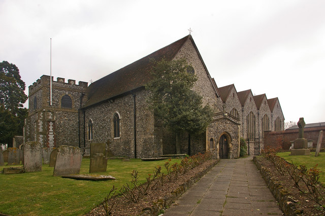
English: All Saints Church This Grade B listed church originally dates from the 12th century, although there are indications of an earlier building here. A tower was added in the 13th century and a porch in the 14th century. For many years it had a taller tower, but this was severely damaged by a storm in 1771, and the subsequent rebuilding was of this shorter castellated version, topped with a steeple. However in 1809 the steeple was struck by lightning and caught fire. It was not replaced, resulting in the present profile of a tower shorter than the surrounding roof.
In 1957, following demolition of Bark Hart House, a Tudor house to the south of the church where Elizabeth I had once stayed, the church was extended over part of the vacated land (the extension can be seen to the right of the photo). For listing particulars see http://www.heritagegateway.org.uk/Gateway/Results_Single.aspx?uid=358379&resourceID=5 |
| Data | |
| Źródło | From geograph.org.uk |
| Autor | Ian Capper |
| Uznanie autorstwa (wymagana przez licencję) | Ian Capper / All Saints Church / |
| Pozycja fotografa | | To i inne zdjęcia na: OpenStreetMap |
|---|
_heading:157.00&language=pl)
| Pozycja obiektu | | To i inne zdjęcia na: OpenStreetMap |
|---|
_heading:157.00&language=pl)
Licencja

|
Ta grafika pochodzi z kolekcji projektu Geograph. Aby zobaczyć szczegóły możesz odwiedzić stronę tego zdjęcia w serwisie Geograph. Prawa autorskie do tej grafiki posiada Ian Capper i jest ona udostępniona na licencji Creative Commons Uznanie autorstwa – Na tych samych warunkach 2.0.
|
Ten plik udostępniony jest na licencji Creative Commons Uznanie autorstwa – Na tych samych warunkach 2.0.
Uznanie autorstwa: Ian Capper
- Wolno:
- dzielić się – kopiować, rozpowszechniać, odtwarzać i wykonywać utwór
- modyfikować – tworzyć utwory zależne
- Na następujących warunkach:
- uznanie autorstwa – musisz określić autorstwo utworu, podać link do licencji, a także wskazać czy utwór został zmieniony. Możesz to zrobić w każdy rozsądny sposób, o ile nie będzie to sugerować, że licencjodawca popiera Ciebie lub Twoje użycie utworu.
- na tych samych warunkach – Jeśli zmienia się lub przekształca niniejszy utwór, lub tworzy inny na jego podstawie, można rozpowszechniać powstały w ten sposób nowy utwór tylko na podstawie tej samej lub podobnej licencji.
Historia pliku
Kliknij na datę/czas, aby zobaczyć, jak plik wyglądał w tym czasie.
| Data i czas | Miniatura | Wymiary | Użytkownik | Opis | |
|---|---|---|---|---|---|
| aktualny | 14:28, 26 lut 2011 | | 640 × 426 (80 KB) | GeographBot | == {{int:filedesc}} == {{Information |description={{en|1=All Saints Church This Grade B listed church originally dates from the 12th century, although there are indications of an earlier building here. A tower was added in the 13th century and a porch in |
Lokalne wykorzystanie pliku
Poniższa strona korzysta z tego pliku:
Globalne wykorzystanie pliku
Ten plik jest wykorzystywany także w innych projektach wiki:
- Wykorzystanie na en.wikipedia.org
- Wykorzystanie na fr.wikipedia.org