
Plik:High Asia Mountain Ranges.jpg

Rozmiar podglądu – 763 × 600 pikseli. Inne rozdzielczości: 306 × 240 pikseli | 611 × 480 pikseli | 978 × 768 pikseli | 1280 × 1006 pikseli | 2560 × 2011 pikseli | 5600 × 4400 pikseli.
Rozmiar pierwotny (5600 × 4400 pikseli, rozmiar pliku: 10,79 MB, typ MIME: image/jpeg)
| Plik High Asia Mountain Ranges.jpg znajduje się w Wikimedia Commons – repozytorium wolnych zasobów. Dane z jego strony opisu znajdują się poniżej. |
Opis
| Opis |
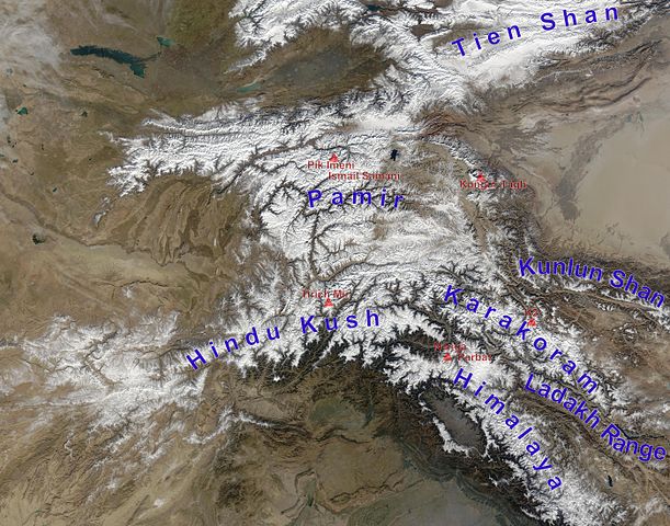
English: high Asian mountain ranges and their highest mountains:
Deutsch: Die innerasiatischen Hochgebirge:
|
| Data | (UTC) |
| Źródło |
Ten plik jest pochodną pracą: Hindu Kush satellite image.jpg: |
| Autor |
|
| To zdjęcie było poddane obróbce cyfrowej i może różnić się od wersji oryginalnej. Zmiany: mountain ranges (and highest mountains) labelled. Oryginał można obejrzeć tu: Hindu Kush satellite image.jpg:
|
Licencja
| Ten plik jest w domenie publicznej ponieważ został stworzony przez NASA. Polityka praw autorskich NASA stwierdza, że „materiały NASA nie są chronione prawami autorskimi, chyba że zapisano inaczej”. (NASA copyright policy lub JPL Image Use Policy). | ||
 |
Uwaga:
|
Oryginalny rejestr przesyłania
This image is a derivative work of the following images:
- File:Hindu_Kush_satellite_image.jpg licensed with PD-USGov-NASA
- 2006-06-06T04:39:19Z Avenue 5600x4400 (5255682 Bytes) {{Information |Description=The Hindu Kush occupies the lower-left-center of this true-color MODIS satellite image, acquired 28 November 2003. |Source=[NASA's Earth Observatory http://earthobservatory.nasa.gov/Newsroom/NewImag
Uploaded with derivativeFX
Historia pliku
Kliknij na datę/czas, aby zobaczyć, jak plik wyglądał w tym czasie.
| Data i czas | Miniatura | Wymiary | Użytkownik | Opis | |
|---|---|---|---|---|---|
| aktualny | 15:05, 27 lis 2012 | | 5600 × 4400 (10,79 MB) | Rupert Pupkin | ladakh range added |
| 13:15, 27 lis 2012 |  | 5600 × 4400 (10,71 MB) | Rupert Pupkin | == {{int:filedesc}} == {{Information |Description=The Hindu Kush occupies the lower-left-center of this true-color MODIS satellite image, acquired 28 November 2003. |Source={{Derived from|Hindu_Kush_satellite_image.jpg|display=50}} |Date=2012-11-27 11:... |
Lokalne wykorzystanie pliku
Poniższa strona korzysta z tego pliku:
Globalne wykorzystanie pliku
Ten plik jest wykorzystywany także w innych projektach wiki:
- Wykorzystanie na af.wikipedia.org
- Wykorzystanie na ba.wikipedia.org
- Wykorzystanie na bcl.wikipedia.org
- Wykorzystanie na bn.wikipedia.org
- Wykorzystanie na ceb.wikipedia.org
- Wykorzystanie na de.wikipedia.org
- Wykorzystanie na en.wikipedia.org
- Wykorzystanie na en.wikivoyage.org
- Wykorzystanie na es.wikipedia.org
- Wykorzystanie na eu.wikipedia.org
- Wykorzystanie na fa.wikipedia.org
- Wykorzystanie na fa.wikivoyage.org
- Wykorzystanie na fr.wikipedia.org
- Wykorzystanie na hy.wikipedia.org
- Wykorzystanie na id.wikipedia.org
- Wykorzystanie na it.wikipedia.org
- Wykorzystanie na lt.wikipedia.org
- Wykorzystanie na ms.wikipedia.org
- Wykorzystanie na nl.wikipedia.org
- Wykorzystanie na pnb.wikipedia.org
- Wykorzystanie na pt.wikipedia.org
- Wykorzystanie na ru.wikipedia.org
- Wykorzystanie na sco.wikipedia.org
- Wykorzystanie na sd.wikipedia.org
- Wykorzystanie na simple.wikipedia.org
- Wykorzystanie na sl.wikipedia.org
- Wykorzystanie na sv.wikipedia.org
- Wykorzystanie na ta.wikipedia.org
Pokaż listę globalnego wykorzystania tego pliku.