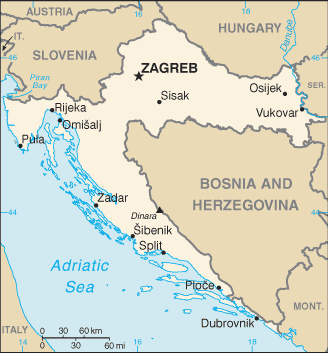
Plik:Hr-map.png
Wygląd
Hr-map.png (328 × 353 pikseli, rozmiar pliku: 15 KB, typ MIME: image/png)
Historia pliku
Kliknij na datę/czas, aby zobaczyć, jak plik wyglądał w tym czasie.
| Data i czas | Miniatura | Wymiary | Użytkownik | Opis | |
|---|---|---|---|---|---|
| aktualny | 03:35, 23 paź 2007 |  | 328 × 353 (15 KB) | Jeroen | CIA map was overwritten by a UN map, I don't think thats the proper of handle things - btw: UN mao will be uploaded in a while |
| 03:06, 13 mar 2007 |  | 894 × 682 (109 KB) | Imbris~commonswiki | UN map of the Republic of Croatia, edited to show correct names of places, and Pelješac on the orriginal is named as an island, not peninsula (it is a peninsula, so green). {{Information |Description=Map of the Republic of Croatia |Source=The Cartogra | |
| 00:59, 10 mar 2007 |  | 2425 × 1805 (1,05 MB) | Minestrone | Larger map | |
| 21:45, 5 mar 2007 |  | 894 × 682 (100 KB) | Imbris~commonswiki | {{Information |Description=Map of Croatia |Source=The Cartographic Section of the United Nations (CSUN) |Date=2004-06-15 |Author=Cartographer of the United Nations |Permission={{Template:UN map}} |other_versions= [http://hr.wikipedia.org/wiki/Slika:UN-Zem | |
| 06:35, 1 lip 2006 |  | 328 × 353 (15 KB) | Hoshie | Updated map of Croatia from the CIA World Factbook, 29 June 06 rev. http://www.cia.gov/cia/publications/factbook/maps/hr-map.gif | |
| 16:53, 3 gru 2004 |  | 330 × 355 (13 KB) | Kneiphof | CIA Croatia map, PD |
Lokalne wykorzystanie pliku
Poniższa strona korzysta z tego pliku:
Globalne wykorzystanie pliku
Ten plik jest wykorzystywany także w innych projektach wiki:
- Wykorzystanie na az.wikipedia.org
- Wykorzystanie na bg.wikipedia.org
- Wykorzystanie na bg.wiktionary.org
- Wykorzystanie na bs.wikipedia.org
- Wykorzystanie na de.wikipedia.org
- Wykorzystanie na de.wiktionary.org
- Wykorzystanie na dsb.wikipedia.org
- Wykorzystanie na en.wikipedia.org
- Wykorzystanie na en.wiktionary.org
- Wykorzystanie na fi.wikipedia.org
- Wykorzystanie na fi.wikivoyage.org
- Wykorzystanie na gag.wikipedia.org
- Wykorzystanie na gl.wikipedia.org
- Wykorzystanie na hif.wikipedia.org
- Wykorzystanie na hr.wikipedia.org
- Wykorzystanie na hr.wiktionary.org
- Wykorzystanie na hu.wikipedia.org
- Wykorzystanie na hu.wiktionary.org
Pokaż listę globalnego wykorzystania tego pliku.


