
Plik:Luzon Strait n7184.jpg

Rozmiar podglądu – 318 × 598 pikseli. Inne rozdzielczości: 127 × 240 pikseli | 542 × 1020 pikseli.
Rozmiar pierwotny (542 × 1020 pikseli, rozmiar pliku: 77 KB, typ MIME: image/jpeg)
| Plik Luzon Strait n7184.jpg znajduje się w Wikimedia Commons – repozytorium wolnych zasobów. Dane z jego strony opisu znajdują się poniżej. |
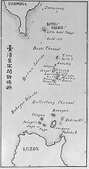
| Opis | Old map of the Luzon Strait (not labeled), including the Bashi Channel, between Orchid Island (Botel Tobago on the map) of Taiwan and the Batan Islands of the Philippines. Names may be out of date. Japanese caption: "Islands between Taiwan and Luzon". | |||||
| Data | nieznana data | |||||
| Źródło |
From digital archive of the University of Tokyo. [1] Cropped by a-giâu. |
|||||
| Autor | anthropologist Torii Ryūzō (1870-1953) | |||||
| Licencja (Ponowne użycie tego pliku) |
|


Historia pliku
Kliknij na datę/czas, aby zobaczyć, jak plik wyglądał w tym czasie.
| Data i czas | Miniatura | Wymiary | Użytkownik | Opis | |
|---|---|---|---|---|---|
| aktualny | 01:30, 12 lis 2004 | | 542 × 1020 (77 KB) | A-giâu | Old map of the Luzon Strait,(not labeled), including the Bashi Channel, between Orchid Island (Botel Tobago in the map) of Taiwan and the Batanes of the Philippines. Names may be out of date. From digital archive of the Universit |
Lokalne wykorzystanie pliku
Poniższa strona korzysta z tego pliku:
Globalne wykorzystanie pliku
Ten plik jest wykorzystywany także w innych projektach wiki:
- Wykorzystanie na ar.wikipedia.org
- Wykorzystanie na ast.wikipedia.org
- Wykorzystanie na az.wikipedia.org
- Wykorzystanie na bcl.wikipedia.org
- Wykorzystanie na be.wikipedia.org
- Wykorzystanie na ca.wikipedia.org
- Wykorzystanie na ceb.wikipedia.org
- Wykorzystanie na cs.wikipedia.org
- Wykorzystanie na da.wikipedia.org
- Wykorzystanie na de.wikipedia.org
- Wykorzystanie na en.wikipedia.org
- Wykorzystanie na es.wikipedia.org
- Wykorzystanie na eu.wikipedia.org
- Wykorzystanie na fa.wikipedia.org
- Wykorzystanie na fr.wikipedia.org
- Wykorzystanie na he.wikipedia.org
- Wykorzystanie na hi.wikipedia.org
- Wykorzystanie na id.wikipedia.org
- Wykorzystanie na ilo.wikipedia.org
- Wykorzystanie na it.wikipedia.org
- Wykorzystanie na ja.wikipedia.org
- Wykorzystanie na ko.wikipedia.org
- Wykorzystanie na lt.wikipedia.org
- Wykorzystanie na mk.wikipedia.org
- Wykorzystanie na nl.wikipedia.org
Pokaż listę globalnego wykorzystania tego pliku.