
Plik:Nouvelle-France map-fr.svg

Rozmiar pierwotny (Plik SVG, nominalnie 1530 × 1090 pikseli, rozmiar pliku: 375 KB)
| Plik Nouvelle-France map-fr.svg znajduje się w Wikimedia Commons – repozytorium wolnych zasobów. Dane z jego strony opisu znajdują się poniżej. |
Opis
| Opis |
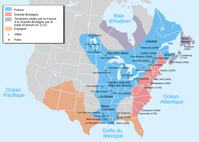
Català: Mapa de la Nova França sobre 1754-1755 English: Map of New France about 1750 using modern political boundaries Español: Mapa de la Nueva Francia cerca de 1750. Français : Carte de la Nouvelle-France vers 1754-1755 Norsk nynorsk: Kart over Ny Frankrike (ca 1754-1755) Русский: Карта Французских колоний в Америке 1750 中文(中国大陆): 1750年左右的新法兰西地图,附现代边界。 العربية : خريطة فرنسا الجديدة حوالي عام 1750 باستخدام الحدود السياسية الحديثة |
||
| Data | |||
| Źródło |
travail personnel from Image:Nouvelle-France1750.png 1) Les Villes françaises du Nouveau Monde : des premiers fondateurs aux ingénieurs du roi, XVIe-XVIIIe siècles / sous la direction de Laurent Vidal et Emilie d'Orgeix /Éditeur : Paris : Somogy 1999. 2) Canada-Québec 1534-2000/ Jacques Lacoursière, Jean Provencher et Denis Vaugeois/Éditeur: Sillery (Québec): Septentrion 2000. |
||
| Autor | Pinpin | ||
| Inne wersje |
File:Nouvelle-France map-fr.svg has 4 translations.
Other related versions:[]
|


|
Ten plik SVG zawiera osadzony tekst, który może być przetłumaczony na Twój język za pomocą odpowiedniego edytora SVG, edytora tekstu lub narzędzia do tłumaczenia SVG. Więcej informacji przeczytasz na stronie O tłumaczeniu plików SVG. |
Ten plik został przetłumaczony z wykorzystaniem elementu SVG <switch>. Wszystkie tłumaczenia są przechowywane w tym samym pliku. Dowiedz się więcej.
Aby umieścić ten plik w twoim języku (jeśli jest dostępny), użyj parametru Aby przetłumaczyć ten plik na swój język, ściągnij go na komputer, dodaj tłumaczenie i załaduj plik ponownie pod tą samą nazwą. Jeśli nie jesteś pewien, jak to zrobić, znajdziesz pomoc na stronie Graphics Lab. |
Licencja

|
Udziela się zgody na kopiowanie, rozpowszechnianie oraz modyfikowanie tego dokumentu zgodnie z warunkami GNU Licencji Wolnej Dokumentacji, w wersji 1.2 lub nowszej opublikowanej przez Free Software Foundation; bez niezmiennych sekcji, bez treści umieszczonych na frontowej lub tylnej stronie okładki. Kopia licencji załączona jest w sekcji zatytułowanej GNU Licencja Wolnej Dokumentacji. |
- Wolno:
- dzielić się – kopiować, rozpowszechniać, odtwarzać i wykonywać utwór
- modyfikować – tworzyć utwory zależne
- Na następujących warunkach:
- uznanie autorstwa – musisz określić autorstwo utworu, podać link do licencji, a także wskazać czy utwór został zmieniony. Możesz to zrobić w każdy rozsądny sposób, o ile nie będzie to sugerować, że licencjodawca popiera Ciebie lub Twoje użycie utworu.
- na tych samych warunkach – Jeśli zmienia się lub przekształca niniejszy utwór, lub tworzy inny na jego podstawie, można rozpowszechniać powstały w ten sposób nowy utwór tylko na podstawie tej samej lub podobnej licencji.
Historia pliku
Kliknij na datę/czas, aby zobaczyć, jak plik wyglądał w tym czasie.
| Data i czas | Miniatura | Wymiary | Użytkownik | Opis | |
|---|---|---|---|---|---|
| aktualny | 19:12, 18 wrz 2023 | | 1530 × 1090 (375 KB) | JoanSMF | File uploaded using svgtranslate tool (https://svgtranslate.toolforge.org/). Added translation for ca. |
| 19:09, 18 wrz 2023 |  | 1530 × 1090 (370 KB) | JoanSMF | File uploaded using svgtranslate tool (https://svgtranslate.toolforge.org/). Added translation for ca. | |
| 21:40, 14 gru 2022 |  | 1530 × 1090 (366 KB) | Tcr25 | Fort Rosaile in wrong location; add Fort St-Jean-Baptiste | |
| 04:14, 23 sie 2021 |  | 1530 × 1090 (353 KB) | Praça de Maio | File uploaded using svgtranslate tool (https://svgtranslate.toolforge.org/). Added translation for tr. | |
| 04:13, 23 sie 2021 |  | 1530 × 1090 (351 KB) | Praça de Maio | File uploaded using svgtranslate tool (https://svgtranslate.toolforge.org/). Added translation for tr. | |
| 13:30, 5 kwi 2020 |  | 1530 × 1090 (343 KB) | Les Meloures | File uploaded using svgtranslate tool (https://tools.wmflabs.org/svgtranslate/). Added translation for lb. | |
| 13:15, 5 kwi 2020 |  | 1530 × 1090 (343 KB) | Les Meloures | File uploaded using svgtranslate tool (https://tools.wmflabs.org/svgtranslate/). Added translation for lb. | |
| 14:59, 12 mar 2020 |  | 1530 × 1090 (326 KB) | Gumruch | Reverted to version as of 11:30, 24 September 2018 (UTC) | |
| 14:58, 12 mar 2020 |  | 1530 × 1090 (342 KB) | Gumruch | File uploaded using svgtranslate tool (https://tools.wmflabs.org/svgtranslate/). Added translation for cs. | |
| 13:30, 24 wrz 2018 |  | 1530 × 1090 (326 KB) | GrandCelinien | Reverted to version as of 22:43, 3 December 2011 (UTC) - La carte est toute floue, ce n'est même plus une vraie SVG. |
Lokalne wykorzystanie pliku
Następujące strony korzystają z tego pliku:
Globalne wykorzystanie pliku
Ten plik jest wykorzystywany także w innych projektach wiki:
- Wykorzystanie na ang.wikipedia.org
- Wykorzystanie na be-tarask.wikipedia.org
- Wykorzystanie na be.wikipedia.org
- Wykorzystanie na bg.wikipedia.org
- Wykorzystanie na ca.wikipedia.org
- Wykorzystanie na co.wikipedia.org
- Wykorzystanie na cs.wikipedia.org
- Wykorzystanie na de.wikipedia.org
- Wykorzystanie na el.wikipedia.org
- Wykorzystanie na eo.wikipedia.org
- Wykorzystanie na fr.wikipedia.org
- Discussion:Québec/Archive 2
- René-Robert Cavelier de La Salle
- Liste des colonies françaises
- Histoire du Canada
- Pierre André de Suffren
- Traité de Versailles (1783)
- Empire colonial français
- Royaume de France
- Histoire de l'Acadie
- Quelques arpents de neige
- Territoires français du nord
- Guerre de la Conquête
- États-Unis
- Franco-Américains
- Utilisateur:Urban/cartes
- Colonisation française des Amériques
- Utilisateur:Xinpeijin/Aide:Captcha
- Portail:Nouvelle-France/Carte de la Nouvelle-France
- Wikipédia:Atelier graphique/Cartes/Archives/décembre 2007
- Liste des forts de la Nouvelle-France
- Discussion utilisateur:The Ogre
- En canot sur les chemins d'eau du Roi
- Vieilles colonies
- Portail:Nouvelle-France
- Histoire de la Louisiane
- Immigration française à Porto Rico
- Histoire de France
- Ferme d'Occident
- Alliance franco-indienne (Amérique)
- Wikipédia:Atelier graphique/Cartes/Archives/Demandes mises en sommeil/Amériques
- Projet:Nouvelle-France/Brasserie Port-Royal/Archives 8
- Colonisation basque des Amériques
Pokaż listę globalnego wykorzystania tego pliku.