
Plik:RedArmy19Aug31Dec44.jpg
Rozmiar podglądu – 788 × 600 pikseli. Inne rozdzielczości: 315 × 240 pikseli | 631 × 480 pikseli | 1009 × 768 pikseli | 1256 × 956 pikseli.
Rozmiar pierwotny (1256 × 956 pikseli, rozmiar pliku: 531 KB, typ MIME: image/jpeg)
| Plik RedArmy19Aug31Dec44.jpg znajduje się w Wikimedia Commons – repozytorium wolnych zasobów. Dane z jego strony opisu znajdują się poniżej. |
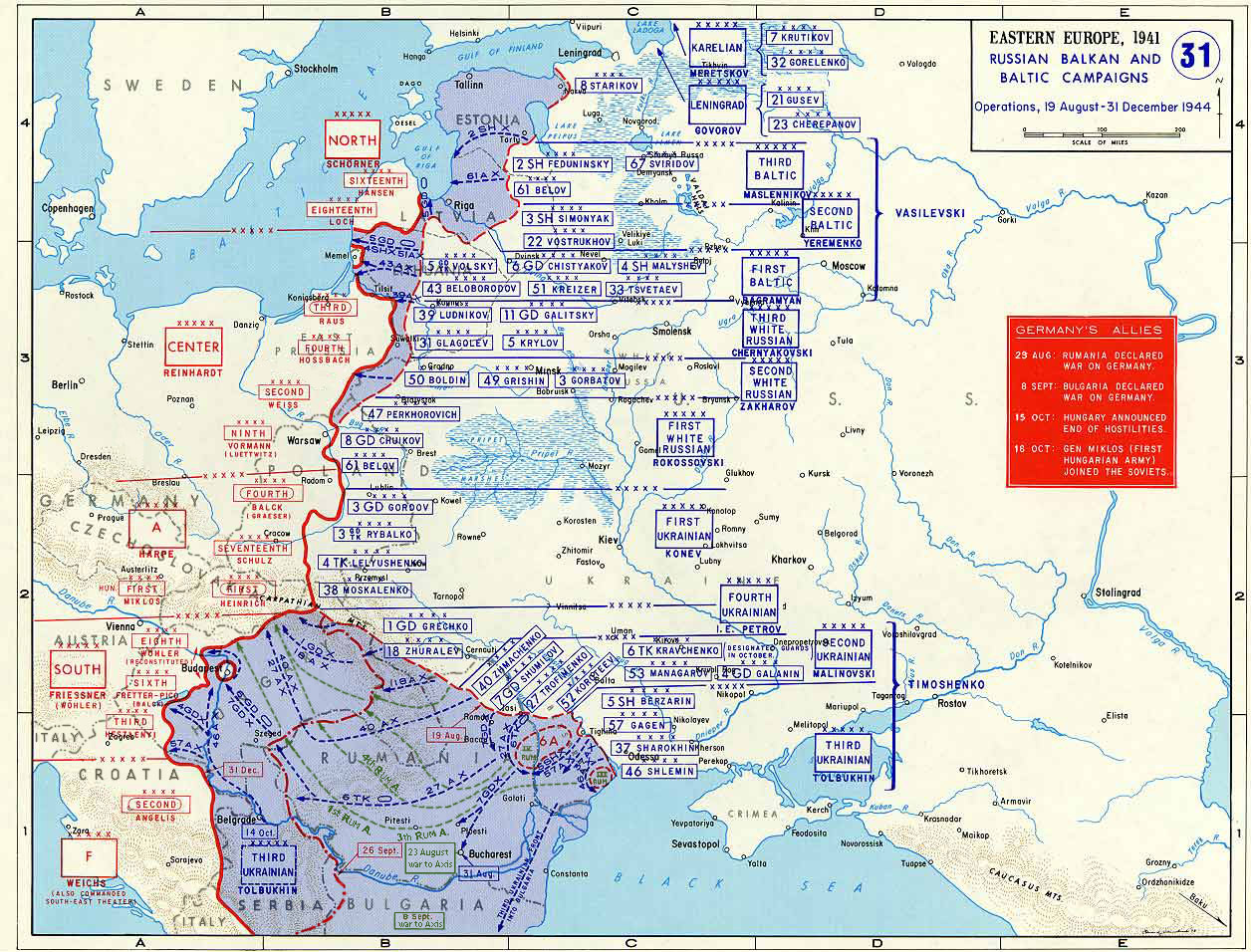
Taken from the campaign series, made public by the US-Army under www.dean.usma.edu The picture is public domain. It shows the situation of the Easter Front from 13. Aug. '44 until 31. Dec. '44
- Source: dean.usma.edu archive copy at the Wayback Machine
From website:
- In 1938 the predecessors of what is today The Department of History at the United States Military Academy began developing a series of campaign atlases to aid in teaching cadets a course entitled, "History of the Military Art." Since then, the Department has produced over six atlases and more than one thousand maps, encompassing not only America’s wars but global conflicts as well.
- In keeping abreast with today's technology, the Department of History is providing these maps on the internet as part of the department's outreach program. The maps were created by the United States Military Academy’s Department of History and are the digital versions from the atlases printed by the United States Defense Printing Agency. We gratefully acknowledge the accomplishments of the department's former cartographer, Mr. Edward J. Krasnoborski, along with the works of our present cartographer, Mr. Frank Martini.
- Please be aware that these maps are large in file size and may require substantial download times.
Ta grafika została utworzona przez pracownika lub żołnierza Armii Stanów Zjednoczonych podczas wykonywania czynności służbowych. Jako utwór Rządu Federalnego Stanów Zjednoczonych, grafika ta znajduje się w domenie publicznej.
|
 |

|
Ta grafika (map) (lub wszystkie grafiki w tym artykule bądź kategorii) powinny zostać przetworzone na grafiki wektorowe jako plik SVG. O zaletach grafik wektorowych można przeczytać na stronie Commons:Media for cleanup. Jeśli wersja SVG tej grafiki jest już dostępna, załaduj ją. Po załadowaniu SVG zamień ten szablon na stronie tej grafiki na szablon {{vector version available|nazwa nowej grafiki.svg}}.
|


Historia pliku
Kliknij na datę/czas, aby zobaczyć, jak plik wyglądał w tym czasie.
| Data i czas | Miniatura | Wymiary | Użytkownik | Opis | |
|---|---|---|---|---|---|
| aktualny | 20:47, 12 sty 2015 | | 1256 × 956 (531 KB) | Spiridon Ion Cepleanu | Borders of years 1940-1944 (rectified some little mistakes) |
| 12:52, 22 kwi 2007 |  | 1256 × 956 (203 KB) | Nasiruddin | Taken from the campaign series, made public by the US-Army under www.dean.usma.edu The picture is public domain. It shows the situation of the Easter Front from 13. Aug. '44 until 31. Dec. '44 *Source: [http://www.dean.usma.edu/history/web03/atlases/grea |
Lokalne wykorzystanie pliku
Poniższa strona korzysta z tego pliku:
Globalne wykorzystanie pliku
Ten plik jest wykorzystywany także w innych projektach wiki:
- Wykorzystanie na ar.wikipedia.org
- Wykorzystanie na ca.wikipedia.org
- Wykorzystanie na cs.wikipedia.org
- Wykorzystanie na de.wikipedia.org
- Wykorzystanie na el.wikipedia.org
- Wykorzystanie na en.wikipedia.org
- Wykorzystanie na es.wikipedia.org
- Wykorzystanie na et.wikipedia.org
- Wykorzystanie na fr.wikipedia.org
- Wykorzystanie na he.wikipedia.org
- Wykorzystanie na id.wikipedia.org
- Wykorzystanie na it.wikipedia.org
- Wykorzystanie na ja.wikipedia.org
- Wykorzystanie na nl.wikipedia.org
- Wykorzystanie na pnb.wikipedia.org
- Wykorzystanie na ro.wikipedia.org
- Wykorzystanie na ru.wikipedia.org
- Wykorzystanie na sh.wikipedia.org
- Wykorzystanie na sr.wikipedia.org
Pokaż listę globalnego wykorzystania tego pliku.